 Dr Suraj Kumar Bhagat, Assistant Professor, Centre for Interdisciplinary Research, published a paper titled “Decoding Rainfall Challenges and Pattern Shift and Trends Using Decomposition and Autocorrelation Function Techniques” in the Q1 journal, Earth Systems and Environment, with an Impact factor of 4.7.
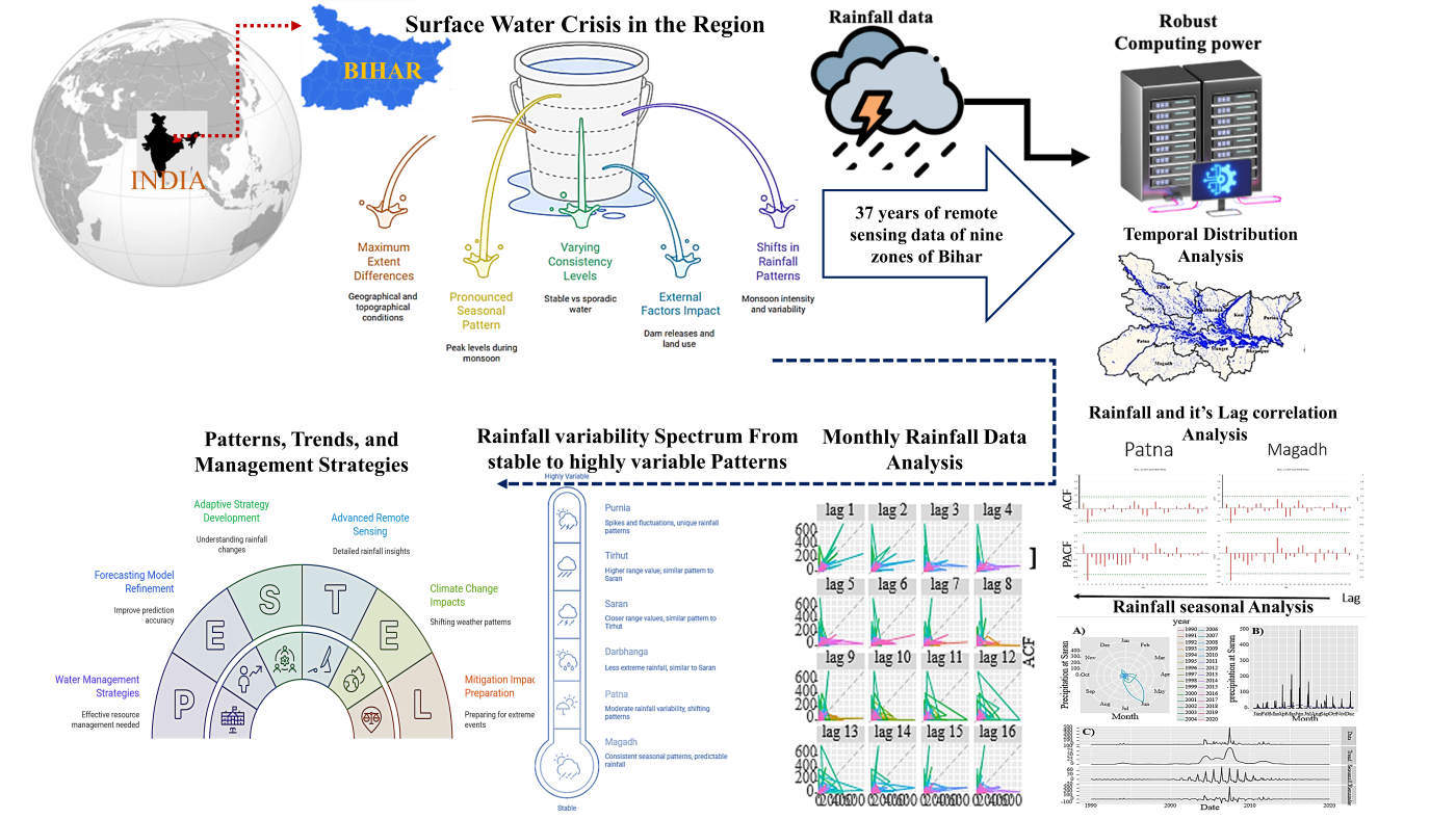
This research examines how rainfall and surface water have changed across nine regions of Bihar between 1984 and 2021, using satellite-based data and statistical methods. Think of it as checking long weather records to see whether the rainy seasons, heavy rains, or dry spells are happening at the same time and with the same strength as before. We used methods that peel away predictable seasonal cycles to reveal hidden shifts and tested whether rainfall events repeat or follow patterns over time.
We found clear differences between northern and southern parts of Bihar. Northern areas like Darbhanga and Kosi get more and more variable rain, making them prone to floods, while southern districts such as Magadh and Bhagalpur tend to have steadier but sometimes reduced water levels. The monsoon — which Indian farming depends on — is showing changes in when it peaks and how intense it is. Recent years (around 2015–2020) show especially noticeable shifts.
In simple terms, rainfall is becoming less predictable in places, which makes farming, water supply and flood protection harder to plan for. The study recommends tailored local forecasting and water management plans so that communities can better prepare for both floods and droughts.
Brief abstract
Ignoring seasonal rainfall trends risks water security and agricultural productivity in Bihar amid climate change. This study analyses 1984–2021 remote-sensing rainfall and surface-water data across nine Bihar zones to decode shifts in seasonality, intensity, and spatial distribution. Using multiple seasonal decomposition (MSTL), autocorrelation (ACF/PACF), and lagged scatterplots, we identify pronounced temporal and spatial disparities: northern zones (Darbhanga, Kosi, Tirhut) show higher variability, recurrence, and flood susceptibility, while southern zones (Magadh, Bhagalpur, Patna) exhibit more stable but sometimes reduced surface water. Monsoon peaks and remainder components display increasing erratic behavior, with 2015–2020 revealing notable pattern shifts. Results call for region-specific adaptive forecasting and water-management strategies that incorporate short- and long-term variability to bolster agricultural resilience and reduce flood–drought risks.
Practical implementation :
This research can help local governments and farmers take concrete, region‑specific actions to manage water better in Bihar. By knowing which areas are heading toward more erratic rain and floods (like Darbhanga and Kosi) and which face more stable but lower water levels (like Magadh and Bhagalpur), authorities can design targeted flood‑protection systems, drainage plans, and reservoir‑operation rules.
For agriculture, the findings support shifting sowing calendars, crop choices, and irrigation schedules to match changing monsoon patterns, reducing the risk of crop failure and income loss for small‑holder farmers. Urban planners in cities such as Patna can use the results to regulate land‑use change, avoid building on flood‑prone lowlands, and protect natural water bodies.
Overall, the study encourages development of district‑level early‑warning systems and climate‑resilient water policies that balance flood mitigation with drought preparedness, improving livelihood security and community safety across Bihar.
Collaborations :
USA; Vietnam; Saudi Arabia; and India
Your future research plans :
Future work will extend this analysis by focusing on recent rainfall shifts (2015–2025) to update and refine forecasting models for Bihar’s nine zones. Research will develop region‑specific predictive models especially for high‑variability areas like Darbhanga, Kosi, and urban Patna by integrating higher‑resolution remote‑sensing data, ground observations, and climate‑model outputs. A key priority is to model extreme rainfall events and their links to flood and drought, using metrics such as skewness and kurtosis to assess risk. Efforts will also explore how climate‑change drivers (temperature rise, land‑use change, glacier‑melt‑driven flows from Nepal) are reshaping local rainfall and river‑flow regimes.
Later phases will couple rainfall forecasts with hydrological and agricultural models to simulate crop yields, water availability, and groundwater stress, enabling robust scenario‑based planning. Finally, future studies will design and test adaptive water‑management interventions—such as dynamic reservoir releases, farm‑level water‑saving practices, and early‑warning systems—through pilot zones before statewide upscaling.
The link to the article
https://doi.org/10.1007/s41748-026-01159-79